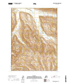
2019 Map of Sutwik Island D-6 NE
USGS Topo · Published 2019About this map
The Aniakchak National Preserve dominates this portion of the Alaska Peninsula, encompassing a dramatic landscape where volcanic terrain meets the drainage basins of the Bristol Bay region. At the heart of the sheet, the prominent rise of Elephant Mtn stands as a significant landmark between the winding paths of Meloy Cr to the west and Cinder River to the east. This 2019 survey illustrates a wilderness defined by its complex hydrologic network, including the meandering course of Wiggly Cr in the northeast. The map provides an essential record of the natural boundaries and topographic features within the preserve, serving as a critical reference for understanding the remote geography of the Lake and Peninsula Borough.
Find a feature on this map
9 named features on this map. Tap any name to fly to it.
Don’t see what you’re looking for? This feature index may not catch every label — zoom into the map to look around manually.
Map Details
Editions of this 2019 Sutwik Island D-6 NE Map
This is the sole edition of this map. No revisions or reprints were ever made.
Other maps of this area

1943 · Ugashik
USGS Topo · 1:250,000

1948 · Ugashik
USGS Topo · 1:250,000

1949 · Ugashik
USGS Topo · 1:250,000

1951 · Sutwik Island
USGS Topo · 1:250,000

1963 · Ugashik A-6
USGS Topo · 1:63,360

1963 · Sutwik Island
USGS Topo · 1:250,000
1963 · Sutwik Island D-5
USGS Topo · 1:63,360
1963 · Sutwik Island D-6
USGS Topo · 1:63,360
1963 · Ugashik A-5
USGS Topo · 1:63,360

1963 · Ugashik
USGS Topo · 1:250,000