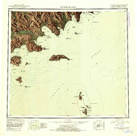
1951 Map of Sutwik Island
USGS Topo · Published 1953About this map
Sutwik Island and the neighboring Semidi National Wildlife Refuge anchor this mid-century reconnaissance study of the Alaska Peninsula’s southeastern coast. The shoreline is characterized by deep glacial indentations and rugged volcanic topography, where the Aniakchak River drains toward the Pacific Ocean from the interior. The landscape is a complex network of coastal features, including the notable Meshik Lake and prominent peaks like Pinnacle Mtn.
Find a feature on this map
58 named features on this map. Tap any name to fly to it.
Don’t see what you’re looking for? This feature index may not catch every label — zoom into the map to look around manually.
Map Details
Editions of this 1951 Sutwik Island Map
4 editions found
Other maps of this area

1943 · Ugashik
USGS Topo · 1:250,000

1948 · Ugashik
USGS Topo · 1:250,000

1949 · Ugashik
USGS Topo · 1:250,000

1951 · Bristol Bay
USGS Topo · 1:250,000

1951 · Trinity Islands
USGS Topo · 1:250,000

1951 · Karluk
USGS Topo · 1:250,000

1951 · Stepovak Bay
USGS Topo · 1:250,000

1951 · Sutwik Island
USGS Topo · 1:250,000

1951 · Ugashik A-2
USGS Topo · 1:63,360

1952 · Karluk
USGS Topo · 1:250,000