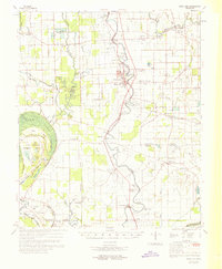
1969 Map of Swan Lake
USGS Topo · Published 1969About this map
The alluvial floodplains of the Mississippi Delta are captured here in 1969, defined by a network of bayous, sloughs, and drainage canals that support a landscape of intensive agriculture. The Illinois Central Railroad serves as the primary spine for commerce, connecting established settlements like Hollandale, Estill, and Nitta Yuma. A significant portion of the western terrain is dedicated to conservation and recreation, notably within the Yazoo National Wildlife Refuge and Leroy Percy State Park, where the waters of Swan Lake and Black Bayou dominate the local geography. Scattered throughout the rural stretches are numerous small churches and family burial grounds, such as Mt Tabor Ch and Huddleston Cem, reflecting the deep-rooted community structure of the era. The map also documents early aviation infrastructure with sites like the Hollandale Municipal Airport and several private landing fields, illustrating the growing importance of aerial application and travel in this agricultural heartland.
Find a feature on this map
101 named features on this map. Tap any name to fly to it.
Don’t see what you’re looking for? This feature index may not catch every label — zoom into the map to look around manually.
Map Details
Editions of this 1969 Swan Lake Map
This is the sole edition of this map. No revisions or reprints were ever made.
Other maps of this area

1909 · Wilsons Point
USGS Topo · 1:24,000

1913 · Wilson Point
USGS Topo · 1:31,680

1939 · Lorenzen
USGS Topo · 1:62,500

1939 · Readland
USGS Topo · 1:62,500

1939 · Refuge
USGS Topo · 1:62,500

1939 · Tralake
USGS Topo · 1:62,500

1939 · Mayersville
USGS Topo · 1:62,500

1939 · Swan Lake
USGS Topo · 1:62,500

1940 · Auter
USGS Topo · 1:62,500

1940 · Baird
USGS Topo · 1:62,500