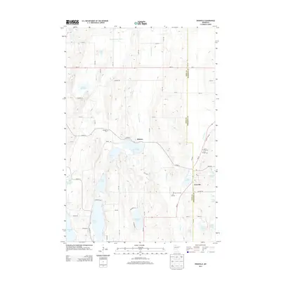
2013 Map of Swanville
USGS Topo · Published 2013About this map
The Swanville and Pillsbury communities anchor this central Minnesota landscape, where the boundary between Todd and Morrison counties follows a north-south line through a complex network of glacial lakes and wetlands. The drainage of the Swan River and its tributaries, including Little Swan River and Spring Br Swan River, defines the local geography. Large water bodies like Big Swan Lake, Long Lake, and Moose Lake dominate the terrain, surrounded by a rural grid of roads such as State 28 and Co Hwy-12. Genealogists will find several significant burial sites mapped, including Bearhead Cem, Spring Brook Cem, and the dual locations of Saint Peter Cem and Saint John Cem. The map provides a clear look at the area's late-twentieth-century rural infrastructure, including the Post Office in Swanville and the numerous named creeks and lakes that have shaped local recreation and settlement for generations.
Find a feature on this map
52 named features on this map. Tap any name to fly to it.
Don’t see what you’re looking for? This feature index may not catch every label — zoom into the map to look around manually.
Map Details
Editions of this 2013 Swanville Map
This is the sole edition of this map. No revisions or reprints were ever made.
Other maps of this area

1947 · Flensburg
USGS Topo · 1:25,000

1948 · Cushing
USGS Topo · 1:62,500

1950 · Swanville
USGS Topo · 1:62,500

1950 · Cushing
USGS Topo · 1:62,500

1951 · Flensburg
USGS Topo · 1:25,000

1953 · Brainerd
USGS Topo · 1:250,000

1953 · Saint Cloud
USGS Topo · 1:250,000

1957 · Brainerd
USGS Topo · 1:250,000

1957 · Saint Cloud
USGS Topo · 1:250,000

1958 · Saint Cloud
USGS Topo · 1:250,000