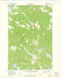
1971 Map of Swatara
USGS Topo · Published 1973About this map
Swatara serves as the primary focal point of this Aitkin County survey, situated where the Soo Line corridor cuts through the northern Minnesota landscape. This era reflects a transition where rail infrastructure and small-scale resource extraction, indicated by several Gravel Pits, intersected with the extensive public lands of the Hill Lake State Forest. The geography is defined by a dense network of glacial water bodies and meandering waterways, including the Willow River and Moose River, which drain the township of Macville. Local genealogy and land-use history are well-represented by named features such as Bible Lake, Kangas Lake, and McKinney Lake, illustrating the pattern of settlement and recreational use in the region during the early 1970s.
Find a feature on this map
16 named features on this map. Tap any name to fly to it.
Don’t see what you’re looking for? This feature index may not catch every label — zoom into the map to look around manually.
Map Details
Editions of this 1971 Swatara Map
This is the sole edition of this map. No revisions or reprints were ever made.
Other maps of this area

1953 · Duluth
USGS Topo · 1:250,000

1954 · Hibbing
USGS Topo · 1:250,000

1957 · Hibbing
USGS Topo · 1:250,000

1958 · Hibbing
USGS Topo · 1:250,000

1958 · Duluth
USGS Topo · 1:250,000

1964 · Hibbing
USGS Topo · 1:250,000

1970 · Edna Lake
USGS Topo · 1:24,000

1970 · Big Thunder Peak
USGS Topo · 1:24,000

1970 · Shovel Lake
USGS Topo · 1:24,000
1970 · Mountain Ash Lake
USGS Topo · 1:24,000