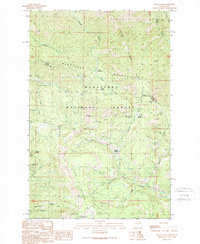
1989 Map of Swauk Pass
USGS Topo · Published 1989About this map
The Wenatchee Mountains define this high-altitude terrain along the boundary between Chelan and Kittitas Counties. This 1989 edition shows the intricate network of forest roads and trails within the Wenatchee National Forest, focusing on the recreational and extractive history of the area. Significant landmarks include the high-elevation Swauk Pass and the extensive Swauk Prospects, indicating the region's mineral interest. The landscape is characterized by a series of prominent meadows such as Tronsen Meadow, Haney Meadow, and Upper Naneum Meadow, which serve as vital openings in the dense forest cover. Numerous small drainages like Scotty Creek and Naneum Creek cut through the slopes beneath Table Mountain and Mission Ridge, while established campgrounds like Tronsen Campground point to the area's long-standing role as a mountain retreat.
Find a feature on this map
28 named features on this map. Tap any name to fly to it.
Don’t see what you’re looking for? This feature index may not catch every label — zoom into the map to look around manually.
Map Details
Editions of this 1989 Swauk Pass Map
2 editions found
Other maps of this area

1897 · Mount Stuart
USGS Topo · 1:125,000

1902 · Mount Stuart
USGS Topo · 1:125,000

1913 · Wenatchee
USGS Topo · 1:62,500

1915 · Wenatchee
USGS Topo · 1:62,500

1920 · Colockum Pass
USGS Topo · 1:125,000

1922 · Colockum Pass
USGS Topo · 1:125,000

1957 · Wenatchee
USGS Topo · 1:250,000

1958 · Thorp
USGS Topo · 1:62,500

1961 · Liberty
USGS Topo · 1:62,500
1966 · Mission Peak
USGS Topo · 1:24,000