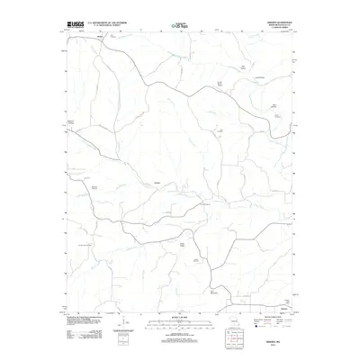
2012 Map of Sweden
USGS Topo · Published 2012About this map
Bryant Creek and its many winding tributaries define this rural landscape of Douglas County, Missouri. The map centers on the small settlements of Larissa and Sweden, the latter of which still maintains the Sweden Post Office in the southeastern corner. This area is heavily marked by its genealogical record, with numerous small burial grounds such as Dyer Cemetery in the north and Whites Creek Cemetery in the southwest, often found near family-named landmarks like Peaky Ridge and Iron Mountain. The drainage pattern is complex, with Wildcat Creek and Hunter Creek flowing through the central hills. Transportation is primarily limited to county routes and local roads, while the Arnika Ranch Airport suggests the continued importance of small-scale aviation for reaching these more secluded sections of the Ozarks.
Find a feature on this map
56 named features on this map. Tap any name to fly to it.
Don’t see what you’re looking for? This feature index may not catch every label — zoom into the map to look around manually.
Map Details
Editions of this 2012 Sweden Map
This is the sole edition of this map. No revisions or reprints were ever made.
Other maps of this area

1936 · Ava
USGS Topo · 1:48,000

1937 · Buckhart
USGS Topo · 1:48,000

1942 · Ava
USGS Topo · 1:62,500

1943 · Buckhart
USGS Topo · 1:62,500

1945 · Ava
USGS Topo · 1:62,500

1945 · Harrison
USGS Topo · 1:250,000

1945 · Buckhart
USGS Topo · 1:62,500

1949 · Harrison
USGS Topo · 1:250,000

1951 · Norwood
USGS Topo · 1:24,000
1951 · Mansfield
USGS Topo · 1:24,000