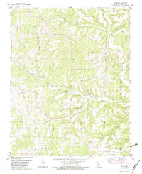
1982 Map of Sweden
USGS Topo · Published 1983About this map
The Crystal Spring Fish Hatchery is a prominent industrial and hydrological fixture within this 1980s landscape, located near the center of the Missouri Ozarks terrain. The small community of Sweden serves as a southern anchor, while Basker marks the northern edge of the survey. The region is defined by a dense network of creek valleys, including Hunter Creek, Bill Macks Creek, and Bryant Creek, which carve through ridges such as Peaky Ridge and Iron Mountain.
Find a feature on this map
38 named features on this map. Tap any name to fly to it.
Don’t see what you’re looking for? This feature index may not catch every label — zoom into the map to look around manually.
Map Details
Editions of this 1982 Sweden Map
This is the sole edition of this map. No revisions or reprints were ever made.
Other maps of this area

1936 · Ava
USGS Topo · 1:48,000

1937 · Buckhart
USGS Topo · 1:48,000

1942 · Ava
USGS Topo · 1:62,500

1943 · Buckhart
USGS Topo · 1:62,500

1945 · Ava
USGS Topo · 1:62,500

1945 · Harrison
USGS Topo · 1:250,000

1945 · Buckhart
USGS Topo · 1:62,500

1949 · Harrison
USGS Topo · 1:250,000

1951 · Norwood
USGS Topo · 1:24,000
1951 · Mansfield
USGS Topo · 1:24,000