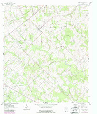
1963 Map of Sweet Home
USGS Topo · Published 1987About this map
Sweet Home serves as the focal point of this rural landscape, situated at the intersection of several regional roads near the Sweet Home Ch and Sweet Home City Cem. The settlement's infrastructure is detailed alongside the Queen of Peace Cem and the Old Railroad Grade, which highlights the area's historical transportation network. To the south, the industrial presence of the South Yoakum Oilfield and various Gas Wells indicates the region's mid-century energy production, while the border of Lavaca Co and De Witt Co cuts through the southwestern corner.
Find a feature on this map
25 named features on this map. Tap any name to fly to it.
Don’t see what you’re looking for? This feature index may not catch every label — zoom into the map to look around manually.
Map Details
Editions of this 1963 Sweet Home Map
2 editions found
Other maps of this area

1953 · Seguin
USGS Topo · 1:250,000

1958 · Seguin
USGS Topo · 1:250,000

1962 · Edgar
USGS Topo · 1:24,000

1962 · Terryville
USGS Topo · 1:24,000

1962 · Hallettsville
USGS Topo · 1:24,000

1963 · Yoakum
USGS Topo · 1:24,000

1963 · Sweet Home
USGS Topo · 1:24,000

1964 · Ezzell
USGS Topo · 1:24,000

1965 · Wied
USGS Topo · 1:24,000

1965 · Hope
USGS Topo · 1:24,000