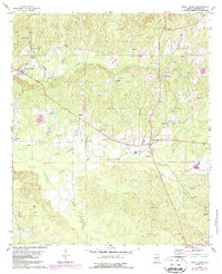
1978 Map of Sweet Water
USGS Topo · Published 1987About this map
Sweet Water and the surrounding Marengo County timberlands are defined by a network of rural settlements and family-named landmarks in this late 1970s survey. The landscape is deeply incised by drainages like Sweetwater Creek, Quinney Branch, and Little Mud Creek, which dictated the placement of early homesteads and community hubs. Small inland settlements such as Wayne, Exmoor, and Vangale appear alongside more established centers like Dixons Mills, where the Dixons Mills Sch and nearby Dixon Cem served generations of local families.
Find a feature on this map
43 named features on this map. Tap any name to fly to it.
Don’t see what you’re looking for? This feature index may not catch every label — zoom into the map to look around manually.
Map Details
Editions of this 1978 Sweet Water Map
2 editions found
Other maps of this area

1953 · Montgomery
USGS Topo · 1:250,000

1953 · Andalusia
USGS Topo · 1:250,000

1956 · Montgomery
USGS Topo · 1:250,000

1957 · Montgomery
USGS Topo · 1:250,000

1957 · Andalusia
USGS Topo · 1:250,000

1973 · Thomasville
USGS Topo · 1:24,000

1978 · Surginer
USGS Topo · 1:24,000

1978 · Sweet Water
USGS Topo · 1:24,000
1978 · Bashi
USGS Topo · 1:24,000
1978 · Nanafalia
USGS Topo · 1:24,000