
1960 Map of Sweetwater
USGS Topo · Published 1961About this map
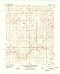
The North Fork Red River snakes through the southern reaches of this landscape, marking a significant boundary just north of Texola. In the early 1960s, the rural community of Sweetwater serves as a local hub, anchored by the Sweetwater High Sch and surrounded by a network of family-named landmarks and country churches like the Assembly of God Ch. The terrain is defined by the drainage of Sweetwater Creek and the various branches of Buffalo Creek, which carve through the townships of Meridian, Berlin, and Buffalo. Genealogy researchers will find a high density of burial grounds across these hills, including Mulberry Cem, Salam Cem, and the Pioneer Cem near the southeastern corner. This survey also captures the early footprints of local industry with several Oil Wells and Gas Wells scattered among the sections, reflecting the era's emerging energy economy.
Find a feature on this map
40 named features on this map. Tap any name to fly to it.
Don’t see what you’re looking for? This feature index may not catch every label — zoom into the map to look around manually.
Map Details
Editions of this 1960 Sweetwater Map
2 editions found
Other maps of this area

1954 · Amarillo
USGS Topo · 1:250,000

1955 · Clinton
USGS Topo · 1:250,000

1957 · Clinton
USGS Topo · 1:250,000

1958 · Amarillo
USGS Topo · 1:250,000

1960 · Cheyenne
USGS Topo · 1:62,500

1960 · Sayre
USGS Topo · 1:62,500

1961 · Reydon
USGS Topo · 1:62,500

1961 · Willow
USGS Topo · 1:62,500

1961 · Erick
USGS Topo · 1:62,500

1962 · Kelton SE
USGS Topo · 1:24,000