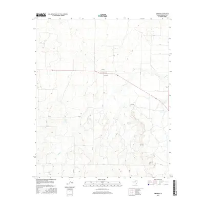
2016 Map of Swenson
USGS Topo · Published 2016About this map
Swenson serves as the central point of this western Stonewall County landscape, where the flat upland plains are carved by the intricate drainage networks of Stinking Cr and K U Cr. The topography here is defined by sudden elevation changes, most notably at Keen Mtn and K U Peak, which overlook the winding creek beds. For those tracing local family history, the map precisely locates the Shadle Cem in the northeast and Aspermont Cem to the south. The road system, including FM 1646 and FM 2211, connects these landmarks to Parker Lake and the various county roads that weave through the ranchlands. The intricate contour lines illustrate how the West Texas terrain drops away from the plateau into the erosion-carved breaks, a pattern typical of this region's geology.
Find a feature on this map
26 named features on this map. Tap any name to fly to it.
Don’t see what you’re looking for? This feature index may not catch every label — zoom into the map to look around manually.
Map Details
Editions of this 2016 Swenson Map
This is the sole edition of this map. No revisions or reprints were ever made.
Other maps of this area

1931 · Aspermont
USGS Topo · 1:62,500

1954 · Lubbock
USGS Topo · 1:250,000

1958 · Seven Diamond L Canyon
USGS Topo · 1:24,000

1958 · Lovers Resort
USGS Topo · 1:24,000

1967 · Kiowa Peak SW
USGS Topo · 1:24,000

1968 · Double Mountains
USGS Topo · 1:24,000
1968 · Aspermont
USGS Topo · 1:24,000
1968 · Coon Hollow
USGS Topo · 1:24,000

1968 · Peacock
USGS Topo · 1:24,000
1968 · Swenson
USGS Topo · 1:24,000