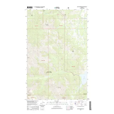
2017 Map of Swift Reservoir
USGS Topo · Published 2017About this map
Swift Reservoir and the headwaters of Birch Creek dominate this landscape within the Lewis & Clark National Forest. The 2017 terrain is defined by high-elevation peaks and ridges, including the prominent Major Steele Backbone and the towering Mt Richmond. These formations are part of a complex system of drainage basins where numerous seasonal and perennial streams like N Fork Whitetail Cr and Haywood Cr carve through the mountain slopes. The map traces the rugged northern boundary of the Teton Co line, where it meets Pondera Co. For those studying the hydrology of the Rocky Mountain Front, the network of named forks and creeks provides a detailed look at how water moves from the high peaks of Feather Woman Mtn and Mt Poia down into the reservoir, which serves as a critical water management feature for the lower plains.
Find a feature on this map
33 named features on this map. Tap any name to fly to it.
Don’t see what you’re looking for? This feature index may not catch every label — zoom into the map to look around manually.
Map Details
Editions of this 2017 Swift Reservoir Map
This is the sole edition of this map. No revisions or reprints were ever made.
Other maps of this area

1913 · Marias Pass
USGS Topo · 1:125,000

1914 · Heart Butte
USGS Topo · 1:125,000

1918 · Heart Butte
USGS Topo · 1:125,000

1960 · Cut Bank
USGS Topo · 1:250,000

1963 · Cut Bank
USGS Topo · 1:250,000

1964 · Cut Bank
USGS Topo · 1:250,000

1968 · Half Dome Crag
USGS Topo · 1:24,000

1968 · Swift Reservoir
USGS Topo · 1:24,000
1968 · Gateway Pass
USGS Topo · 1:24,000

1968 · Fish Lake
USGS Topo · 1:24,000