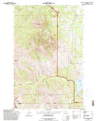
1995 Map of Swift Reservoir
USGS Topo · Published 1997About this map
The Sawtooth Range dominates this landscape along the Rocky Mountain Front, where the High Plains meet the dramatic uplift of the Lewis and Clark National Forest. This 1995 revision reveals a complex intersection of administrative boundaries, as the Blackfeet Indian Reservation meets the eastern edge of the mountains, and the Bob Marshall Wilderness occupies the southern reaches of the quadrangle. The distinct Major Steele Backbone and peaks such as Feather Woman Mountain and Mount Poia define the crests, while the drainage of Birch Creek flows toward the Swift Reservoir at the eastern margin. The map captures a high-elevation wilderness before more recent environmental changes, preserving the locations of remote landmarks like Mowitch Basin and the Reservation Boundary as they were surveyed in the mid-1990s.
Find a feature on this map
29 named features on this map. Tap any name to fly to it.
Don’t see what you’re looking for? This feature index may not catch every label — zoom into the map to look around manually.
Map Details
Editions of this 1995 Swift Reservoir Map
This is the sole edition of this map. No revisions or reprints were ever made.
Other maps of this area

1913 · Marias Pass
USGS Topo · 1:125,000

1914 · Heart Butte
USGS Topo · 1:125,000

1918 · Heart Butte
USGS Topo · 1:125,000

1960 · Cut Bank
USGS Topo · 1:250,000

1963 · Cut Bank
USGS Topo · 1:250,000

1964 · Cut Bank
USGS Topo · 1:250,000

1968 · Half Dome Crag
USGS Topo · 1:24,000

1968 · Swift Reservoir
USGS Topo · 1:24,000
1968 · Gateway Pass
USGS Topo · 1:24,000

1968 · Fish Lake
USGS Topo · 1:24,000