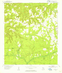
1955 Map of Sycamore
USGS Topo · Published 1956About this map
The Forbes Purchase boundary lines define the southern landscape of Gadsden County in the mid-1950s, where small settlements and rural congregations are connected by a web of creeks and timbered ridges. This survey illustrates a period of agrarian transition, centered on Sycamore and the rail-oriented Greensboro at the eastern edge. Local life is anchored by country churches like Pine Grove Ch and St James Ch, alongside the Salem Sch. The topography is deeply dissected by drainage systems including Flat Creek, Yon Creek, and Telogia Creek, which create the winding, hilly terrain that characterizes this part of the Florida Panhandle. The presence of the Apalachicola Northern railroad through the southeastern corner highlights the importance of rail transport for the region's timber and agricultural exports during this era.
Find a feature on this map
33 named features on this map. Tap any name to fly to it.
Don’t see what you’re looking for? This feature index may not catch every label — zoom into the map to look around manually.
Map Details
Editions of this 1955 Sycamore Map
2 editions found
Other maps of this area

1943 · Lake Talquin
USGS Topo · 1:62,500

1945 · Hosford
USGS Topo · 1:31,680

1945 · Bristol
USGS Topo · 1:31,680

1954 · Sneads
USGS Topo · 1:24,000

1954 · Tallahassee
USGS Topo · 1:250,000

1955 · Rock Bluff
USGS Topo · 1:24,000

1955 · Sycamore
USGS Topo · 1:24,000

1955 · Chattahoochee
USGS Topo · 1:24,000

1955 · Mt Pleasant
USGS Topo · 1:24,000

1959 · Tallahassee
USGS Topo · 1:250,000