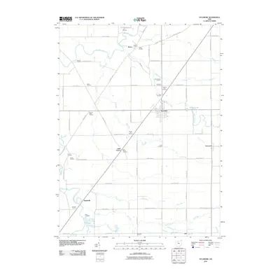
2010 Map of Sycamore
USGS Topo · Published 2010About this map
The Sandusky River winds through the northwest corner of this Wyandot County landscape, defining a rural region centered on the village of Sycamore. This 2010 survey reflects a deeply rooted agricultural community where family-named cemeteries such as the Bibler Cemetery, Bretz Farm Cemetery, and Curlis Cemetery are scattered among the township roads. Small settlements like Belle Vernon and Smithville dot the grid of county highways, while the southern reaches are marked by the waters of Ellis Lake and the Ellis Lake Dam. The terrain is etched by numerous small waterways, including Sycamore Creek, Sugar Run, and Negro Run, which serve as the primary natural drainage for the surrounding fields. Local history is preserved in the location of landmarks like Camp Pittenger and several distinct burial grounds, such as the Old Sycamore Cemetery and Quaker Hill Cemetery, providing a detailed look at the area's social and physical geography.
Find a feature on this map
70 named features on this map. Tap any name to fly to it.
Don’t see what you’re looking for? This feature index may not catch every label — zoom into the map to look around manually.
Map Details
Editions of this 2010 Sycamore Map
This is the sole edition of this map. No revisions or reprints were ever made.
Other maps of this area

1901 · Fostoria
USGS Topo · 1:62,500

1903 · Fostoria
USGS Topo · 1:62,500

1906 · Sycamore
USGS Topo · 1:62,500

1906 · Tiffin
USGS Topo · 1:62,500

1907 · Upper Sandusky
USGS Topo · 1:62,500

1950 · Marion
USGS Topo · 1:250,000

1956 · Toledo
USGS Topo · 1:250,000

1960 · Sycamore
USGS Topo · 1:24,000

1960 · Tiffin South
USGS Topo · 1:24,000

1960 · Oceola
USGS Topo · 1:24,000