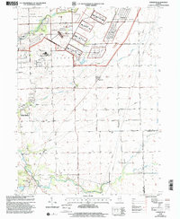
1999 Map of Symerton
USGS Topo · Published 2002About this map
Midewin National Tallgrass Prairie dominates the northern landscape of this survey, illustrating a massive ecological restoration effort on land previously held by the Dept of Army. The map documents a complex transition of land use where military installations and industrial sites, including a Gravel Pit and Sewage Disposal plant, sit alongside protected natural areas like the Forsythe Woods Co Forest Preserve.
Find a feature on this map
36 named features on this map. Tap any name to fly to it.
Don’t see what you’re looking for? This feature index may not catch every label — zoom into the map to look around manually.
Map Details
Editions of this 1999 Symerton Map
This is the sole edition of this map. No revisions or reprints were ever made.
Other maps of this area

1892 · Wilmington
USGS Topo · 1:62,500

1918 · Wilmington
USGS Topo · 1:62,500

1922 · Kankakee
USGS Topo · 1:62,500

1923 · Herscher
USGS Topo · 1:62,500

1924 · Kankakee
USGS Topo · 1:62,500

1925 · Herscher
USGS Topo · 1:62,500

1929 · Brisbane
USGS Topo · 1:24,000

1949 · Peotone
USGS Topo · 1:62,500
1953 · Manhattan
USGS Topo · 1:24,000

1953 · Wilton Center
USGS Topo · 1:24,000