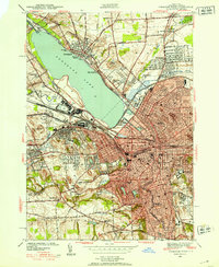
1939 Map of Syracuse West
USGS Topo · Published 1939About this map
Syracuse and its western industrial and residential suburbs are shown here just before the mid-century expansion, centered on the southeastern shores of Onondaga Lake. The city's core is densely plotted, anchored by civic landmarks like City Hall and the Courthouse, while the campus of Syracuse University and the sprawling Oakwood Cemetery define the southeastern quadrant. This era was defined by the transition from early salt-related industry to heavy manufacturing and transport, evidenced by the Salt Springs label near Galeville and the intricate network of the New York Central and Delaware Lackawanna and Western RR. To the west, the village of Solvay stands as a significant industrial hub near the State Fairgrounds, while history is commemorated at Fort Ste Marie De Gannentaha and the Salt Museum along the lakefront Onondaga Lake Park.
Find a feature on this map
56 named features on this map. Tap any name to fly to it.
Don’t see what you’re looking for? This feature index may not catch every label — zoom into the map to look around manually.
Map Details
Editions of this 1939 Syracuse West Map
3 editions found
Other maps of this area

1895 · Syracuse
USGS Topo · 1:62,500

1898 · Syracuse
USGS Topo · 1:62,500

1899 · Skaneateles
USGS Topo · 1:62,500

1900 · Baldwinsville
USGS Topo · 1:62,500

1900 · Tully
USGS Topo · 1:62,500

1902 · Skaneateles
USGS Topo · 1:62,500

1938 · Syracuse East
USGS Topo · 1:24,000

1939 · Syracuse West
USGS Topo · 1:24,000

1940 · Brewerton
USGS Topo · 1:24,000

1940 · Cicero
USGS Topo · 1:24,000