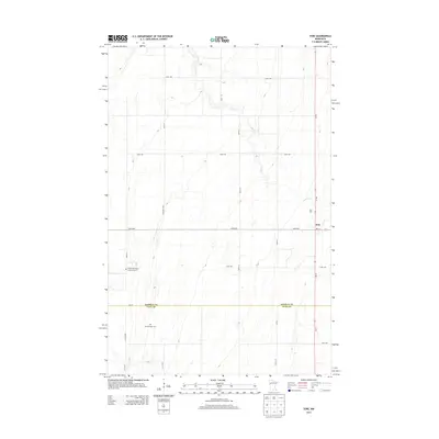
2013 Map of Syre
USGS Topo · Published 2013About this map
The small settlement of Syre anchors this corner of the Red River Valley, situated at the junction of MN-32 and MN-113. This region is defined by a strictly surveyed grid of county roads and avenues that cross the flat agricultural landscape, interrupted only by the winding path of Coon Cr. The map highlights a rich local heritage through its burial grounds, including the Syre Cem and the United Norwegian Lutheran Cem, which reflect the area's Scandinavian settlement history. Further south, near the Norman Co and Clay Co border, the Old Jevnaker Cem sits along a quiet section of 200th Ave. Aside from the primary transportation corridors, a large Wildlife Area occupies a significant portion of the western territory, preserving a natural break in the surrounding farmland.
Find a feature on this map
26 named features on this map. Tap any name to fly to it.
Don’t see what you’re looking for? This feature index may not catch every label — zoom into the map to look around manually.
Map Details
Editions of this 2013 Syre Map
This is the sole edition of this map. No revisions or reprints were ever made.
Other maps of this area

1918 · Twin Valley
USGS Topo · 1:62,500

1918 · Flom
USGS Topo · 1:62,500

1918 · Ulen
USGS Topo · 1:62,500

1952 · Grand Forks
USGS Topo · 1:250,000

1956 · Grand Forks
USGS Topo · 1:250,000

1965 · Waukon
USGS Topo · 1:24,000

1965 · Twin Valley SW
USGS Topo · 1:24,000

1965 · Twin Valley
USGS Topo · 1:24,000

1965 · Syre
USGS Topo · 1:24,000
1965 · Ulen NW
USGS Topo · 1:24,000