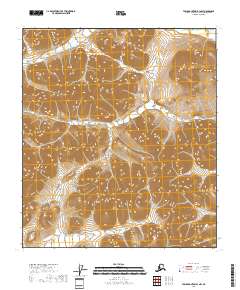
2018 Map of Table Mountain B-3 NW
USGS Topo · Published 2018About this map
The Yukon-Koyukuk Borough and Census Area contains this high-elevation Alaskan wilderness, where the landscape is defined by massive ridges and drainages. The topography is meticulously captured through 20-foot contour intervals, revealing a complex network of unnamed peaks and valleys across several townships, including t11s r40e and t12s r41e. This interior region represents some of the most isolated terrain in North America, with no roads or named settlements shown on the map, focusing instead on the raw physical geography of the Brooks Range foothills. Researchers can trace the intricate natural drainage patterns that feed into the larger river systems of the Yukon-Koyukuk interior.
Find a feature on this map
5 named features on this map. Tap any name to fly to it.
Don’t see what you’re looking for? This feature index may not catch every label — zoom into the map to look around manually.
Map Details
Editions of this 2018 Table Mountain B-3 NW Map
This is the sole edition of this map. No revisions or reprints were ever made.
Other maps of this area

1951 · Table Mountain
USGS Topo · 1:250,000

1956 · Table Mountain
USGS Topo · 1:250,000

1964 · Table Mountain
USGS Topo · 1:250,000
1972 · Table Mountain B-3
USGS Topo · 1:63,360
1972 · Table Mountain B-4
USGS Topo · 1:63,360
1983 · Table Mountain C-3
USGS Topo · 1:63,360
1983 · Table Mountain C-4
USGS Topo · 1:63,360
2018 · Table Mountain C-3 SE
USGS Topo · 1:25,000
2018 · Table Mountain B-3 NE
USGS Topo · 1:25,000
2018 · Table Mountain C-3 SW
USGS Topo · 1:25,000