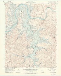
1956 Map of Table Rock Dam
USGS Topo · Published 1968About this map
The Table Rock Dam (Under Construction) stands as the centerpiece of this mid-century survey, capturing the massive engineering project as it began to transform the White River valley. The map documents the landscape just before the completion of the reservoir, showing the original winding river channel upstream of the dam site and the established waters of Lake Taneycomo to the northeast. Settlement patterns of the Ozark hills are preserved through several small country churches and family burial grounds, including Cedar Valley Ch, Bowman Ch, and the Snowden Cem. This area, partly situated within the Mark Twain National Forest, features significant topographical landmarks like Compton Ridge and Table Rock Mountain. The survey also marks local industry of the era, such as a Borrow Pit and Quarry near the construction zone, while tracing the complex borders between Missouri and Arkansas.
Find a feature on this map
40 named features on this map. Tap any name to fly to it.
Don’t see what you’re looking for? This feature index may not catch every label — zoom into the map to look around manually.
Map Details
Editions of this 1956 Table Rock Dam Map
5 editions found
Other maps of this area

1904 · Harrison
USGS Topo · 1:125,000

1905 · Harrison
USGS Topo · 1:125,000

1907 · Forsyth
USGS Topo · 1:125,000

1945 · Harrison
USGS Topo · 1:250,000

1949 · Harrison
USGS Topo · 1:250,000

1950 · Garber
USGS Topo · 1:24,000

1954 · Harrison
USGS Topo · 1:250,000

1956 · Lampe
USGS Topo · 1:24,000

1956 · Table Rock Dam
USGS Topo · 1:24,000

1956 · Garber
USGS Topo · 1:24,000