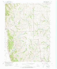
1957 Map of Tabor SW
USGS Topo · Published 1973About this map
Thurman and the outskirts of Sidney anchor this 1950s study of the Fremont County landscape, where the terrain transitions from the Missouri River floodplain toward the interior hills. The topography is defined by an intricate network of waterways, including Plum Creek, Camp Creek, and Dutch Hollow Creek, which have carved deep drainages across the townships of Scott, Green, and Sidney.
Find a feature on this map
21 named features on this map. Tap any name to fly to it.
Don’t see what you’re looking for? This feature index may not catch every label — zoom into the map to look around manually.
Map Details
Editions of this 1957 Tabor SW Map
2 editions found

Other maps of this area

1907 · Nebraska City
USGS Topo · 1:62,500

1935 · Nehawka
USGS Topo · 1:48,000

1939 · Hamburg
USGS Topo · 1:62,500

1940 · Nehawka
USGS Topo · 1:62,500

1941 · Hamburg
USGS Topo · 1:62,500

1955 · Nebraska City
USGS Topo · 1:250,000

1956 · Rock Bluff
USGS Topo · 1:24,000

1957 · Nebraska City
USGS Topo · 1:250,000

1957 · Randolph
USGS Topo · 1:24,000

1957 · Tabor
USGS Topo · 1:24,000