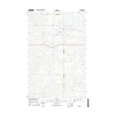
2014 Map of Tagus
USGS Topo · Published 2014About this map
The small settlement of Tagus sits at a geographic crossroads along the boundary of Ward Co and Mountrail Co in this 2014 survey. The landscape is defined by the prairie potholes and depressions characteristic of the North Dakota drift plain, a terrain that influences the local road grid. Transportation through the region relies on Old Highway 2 and CR-5w, which serve as the primary arteries connecting the dispersed agricultural operations. The map provides a detailed view of the rural infrastructure, from the intersecting section lines of 128th Ave NW and 380th St NW to the numerous seasonal wetlands that dot the surrounding acreage near the county line.
Find a feature on this map
19 named features on this map. Tap any name to fly to it.
Don’t see what you’re looking for? This feature index may not catch every label — zoom into the map to look around manually.
Map Details
Editions of this 2014 Tagus Map
This is the sole edition of this map. No revisions or reprints were ever made.
Other maps of this area

1949 · Hartland
USGS Topo · 1:24,000

1953 · Williston
USGS Topo · 1:250,000

1954 · Minot
USGS Topo · 1:250,000

1957 · Williston
USGS Topo · 1:250,000

1958 · Minot
USGS Topo · 1:250,000

1980 · Minot
USGS Topo · 1:100,000

1980 · Tagus SE
USGS Topo · 1:24,000
1980 · Aurelia
USGS Topo · 1:24,000

1980 · Tagus
USGS Topo · 1:24,000
1980 · Plaza NE
USGS Topo · 1:24,000