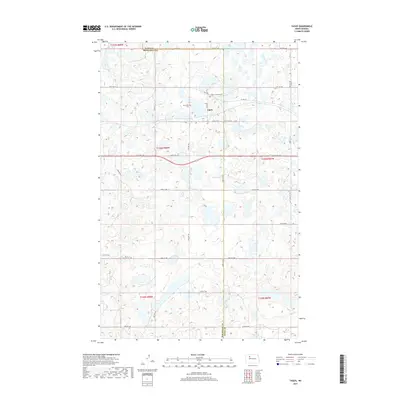
2017 Map of Tagus
USGS Topo · Published 2017About this map
Tagus sits at the intersection of the prairie and the political line separating Ward and Mountrail counties. This North Dakota landscape is defined by its glacial potholes and small wetlands, which dot the township lines from t157n r88w down to the shores of Carpenter Lake. Local heritage is anchored by two distinct burial grounds, Tagus Lutheran Cem and Saint Olaf Cem, which serve as quiet markers of the Scandinavian heritage that shaped this region's farming community. The transport network reflects a transition from historic routes to modern section lines, featuring Old Hwy 2 alongside a grid of gravel roads like 64th St NW and 408th St NW that facilitate the movement of grain and machinery across the Great Plains.
Find a feature on this map
35 named features on this map. Tap any name to fly to it.
Don’t see what you’re looking for? This feature index may not catch every label — zoom into the map to look around manually.
Map Details
Editions of this 2017 Tagus Map
This is the sole edition of this map. No revisions or reprints were ever made.
Other maps of this area

1949 · Hartland
USGS Topo · 1:24,000

1953 · Williston
USGS Topo · 1:250,000

1954 · Minot
USGS Topo · 1:250,000

1957 · Williston
USGS Topo · 1:250,000

1958 · Minot
USGS Topo · 1:250,000

1980 · Minot
USGS Topo · 1:100,000

1980 · Tagus SE
USGS Topo · 1:24,000
1980 · Aurelia
USGS Topo · 1:24,000

1980 · Tagus
USGS Topo · 1:24,000
1980 · Plaza NE
USGS Topo · 1:24,000