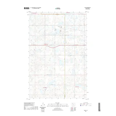
2020 Map of Tagus
USGS Topo · Published 2020About this map
Tagus serves as a small focal point in this portion of the northern plains, situated exactly along the boundary where Mountrail Co meets Ward County. The town is flanked by two sites of genealogical significance: Tagus Lutheran Cem to the north and Saint Olaf Cem just to the west. This 2020 edition reveals a landscape dominated by a high density of small prairie potholes and wetlands, which influence the winding paths of rural connectors like Old Hwy 2 and Co Rd 5W. The local road network, including Tagus St and 64th St NW, follows the standard rectangular survey grid, yet frequently yields to the natural depressions and water bodies that characterize this glaciated terrain.
Find a feature on this map
29 named features on this map. Tap any name to fly to it.
Don’t see what you’re looking for? This feature index may not catch every label — zoom into the map to look around manually.
Map Details
Editions of this 2020 Tagus Map
This is the sole edition of this map. No revisions or reprints were ever made.
Other maps of this area

1949 · Hartland
USGS Topo · 1:24,000

1953 · Williston
USGS Topo · 1:250,000

1954 · Minot
USGS Topo · 1:250,000

1957 · Williston
USGS Topo · 1:250,000

1958 · Minot
USGS Topo · 1:250,000

1980 · Minot
USGS Topo · 1:100,000

1980 · Tagus SE
USGS Topo · 1:24,000
1980 · Aurelia
USGS Topo · 1:24,000

1980 · Tagus
USGS Topo · 1:24,000
1980 · Plaza NE
USGS Topo · 1:24,000