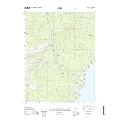
2021 Map of Tahoe City
USGS Topo · Published 2021About this map
Tahoe City and its neighboring communities are meticulously documented in this contemporary survey, illustrating the complex intersection of residential development and protected wilderness on the western shore of Lake Tahoe. The terrain is defined by dramatic elevations and drainage systems, where the Truckee River begins its course and landmarks like Mt Watson and Ward Peak frame the horizon. The landscape is a network of modern recreation and transit, with the Pacific Crest National Scenic Trail traversing the ridgelines while specialized routes such as the Pole Creek Nordic Trail and Western States Trail crisscross the Tahoe National Forest. Insights into the local footprint are visible through the layout of settlements like Sunnyside-Tahoe City and Alpine Meadows, along with cultural points such as Trails End Cemetery. This record reflects the area's role as a major hub for alpine activity, centered around the geography of Squaw Valley and Thunder Cliff.
Find a feature on this map
98 named features on this map. Tap any name to fly to it.
Don’t see what you’re looking for? This feature index may not catch every label — zoom into the map to look around manually.
Map Details
Editions of this 2021 Tahoe City Map
This is the sole edition of this map. No revisions or reprints were ever made.
Other maps of this area

1891 · Truckee
USGS Topo · 1:125,000

1893 · Truckee
USGS Topo · 1:125,000

1895 · Truckee
USGS Topo · 1:125,000

1932 · Truckee
USGS Topo · 1:96,000

1940 · Truckee
USGS Topo · 1:125,000

1953 · Granite Chief
USGS Topo · 1:24,000
1953 · Wentworth Springs
USGS Topo · 1:24,000

1953 · Granite Chief
USGS Topo · 1:62,500
1955 · Homewood
USGS Topo · 1:24,000

1955 · Truckee
USGS Topo · 1:24,000