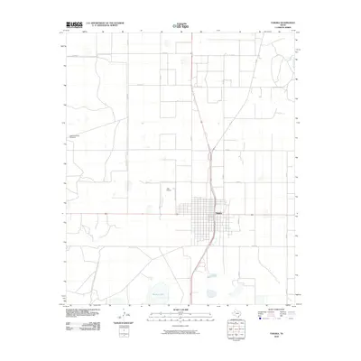
2010 Map of Tahoka
USGS Topo · Published 2010About this map
Tahoka serves as the central hub of this South Plains landscape, where the grid-like precision of cotton-farming country meets the natural depressions of the Llano Estacado. The town is defined by a dense street network including Ave J and Mearl St, bordered to the west by the T-Bar Airport and Country Club Ln. South of the main settlement, the terrain transitions toward Guthrie Lake, a significant water feature in an otherwise dry, agricultural expanse. The presence of the HighLonesome Windmill to the northwest underscores the region's reliance on groundwater and the traditional methods used to sustain livestock and homesteads. This 2010 survey illustrates a well-ordered rural infrastructure, where named county roads like Sam Rd and Co Rd 18 divide the territory into vast sections, typical of Lynn County's development in the early 21st century.
Find a feature on this map
18 named features on this map. Tap any name to fly to it.
Don’t see what you’re looking for? This feature index may not catch every label — zoom into the map to look around manually.
Map Details
Editions of this 2010 Tahoka Map
This is the sole edition of this map. No revisions or reprints were ever made.
Other maps of this area

1954 · Lubbock
USGS Topo · 1:250,000

1957 · New Home
USGS Topo · 1:62,500

1965 · Wilson
USGS Topo · 1:24,000

1969 · Skeen Lake
USGS Topo · 1:24,000

1969 · Tahoka
USGS Topo · 1:24,000
1969 · Tahoka SW
USGS Topo · 1:24,000

1969 · Double Lakes
USGS Topo · 1:24,000

1970 · New Lynn
USGS Topo · 1:24,000
1970 · Draw
USGS Topo · 1:24,000
1976 · New Home SE
USGS Topo · 1:24,000