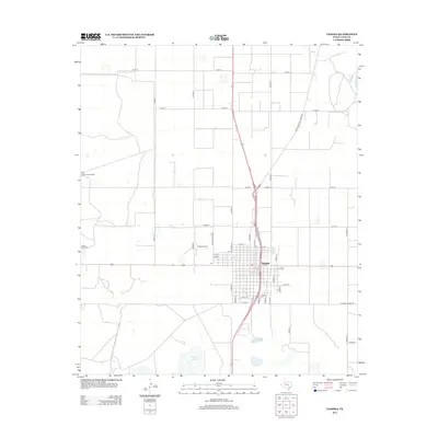
2012 Map of Tahoka
USGS Topo · Published 2012About this map
Tahoka serves as the central hub of this Lynn County landscape, organized by a rigid grid of residential streets and arterial roads. The town's layout is defined by north-south corridors like Avenue P N and Avenue Q, while Main St and Frontage Rd parallel the highway that bisects the community. To the west, the arid High Plains environment is punctuated by vital water resources such as the High Lonesome Windmill and Hook Windmill, which denote the region's ranching heritage and reliance on groundwater. Beyond the town limits, the terrain opens into a vast network of section roads, including Farm-To-Market Road 400, which connect the rural interior to local aviation at the T-Bar Airport and natural basins like Tahoka Lake and Guthrie Lake.
Find a feature on this map
46 named features on this map. Tap any name to fly to it.
Don’t see what you’re looking for? This feature index may not catch every label — zoom into the map to look around manually.
Map Details
Editions of this 2012 Tahoka Map
This is the sole edition of this map. No revisions or reprints were ever made.
Other maps of this area

1954 · Lubbock
USGS Topo · 1:250,000

1957 · New Home
USGS Topo · 1:62,500

1965 · Wilson
USGS Topo · 1:24,000

1969 · Skeen Lake
USGS Topo · 1:24,000

1969 · Tahoka
USGS Topo · 1:24,000
1969 · Tahoka SW
USGS Topo · 1:24,000

1969 · Double Lakes
USGS Topo · 1:24,000

1970 · New Lynn
USGS Topo · 1:24,000
1970 · Draw
USGS Topo · 1:24,000
1976 · New Home SE
USGS Topo · 1:24,000