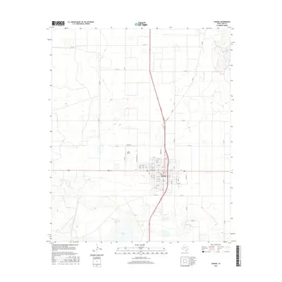
2016 Map of Tahoka
USGS Topo · Published 2016About this map
Tahoka serves as the focal point of this Lynn County landscape, positioned within a grid-based agricultural region defined by expansive playa lakes and section roads. The town's layout is meticulously detailed, showing the residential and commercial structure between N 8th and S 11th St, with Lockwood St serving as a central east-west axis. The surrounding High Plains terrain is marked by distinctive depressions, most notably the large saline basins of Guthrie Lake to the southwest and Tahoka Lake in the northeast corner. These natural landmarks contrast with the straight-line geometry of the local infrastructure, including the T-Bar Airport and the network of county roads like Co Rd 18 and Co Rd 25 that partition the surrounding cotton-growing country.
Find a feature on this map
32 named features on this map. Tap any name to fly to it.
Don’t see what you’re looking for? This feature index may not catch every label — zoom into the map to look around manually.
Map Details
Editions of this 2016 Tahoka Map
This is the sole edition of this map. No revisions or reprints were ever made.
Other maps of this area

1954 · Lubbock
USGS Topo · 1:250,000

1957 · New Home
USGS Topo · 1:62,500

1965 · Wilson
USGS Topo · 1:24,000

1969 · Skeen Lake
USGS Topo · 1:24,000

1969 · Tahoka
USGS Topo · 1:24,000
1969 · Tahoka SW
USGS Topo · 1:24,000

1969 · Double Lakes
USGS Topo · 1:24,000

1970 · New Lynn
USGS Topo · 1:24,000
1970 · Draw
USGS Topo · 1:24,000
1976 · New Home SE
USGS Topo · 1:24,000