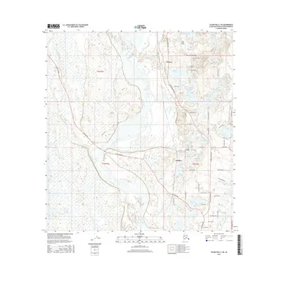
2016 Map of Talkeetna A-1 NE
USGS Topo · Published 2016About this map
The Susitna River dominates this interior landscape, carving a complex network of channels and braids that define the local geography north of Sunshine. This 2016 survey illustrates the modern road network extending from the Parks Highway and Talkeetna Spur Road, which provides the primary access to the settlement of Talkeetna. The area is characterized by an abundance of water bodies, many with evocative names like Question Lake, Answer Creek, and the numbered series including Lake Two through Lake Six.
Find a feature on this map
74 named features on this map. Tap any name to fly to it.
Don’t see what you’re looking for? This feature index may not catch every label — zoom into the map to look around manually.
Map Details
Editions of this 2016 Talkeetna A-1 NE Map
This is the sole edition of this map. No revisions or reprints were ever made.
Other maps of this area

1949 · Talkeetna Mountains B-6
USGS Topo · 1:63,360

1950 · Talkeetna Mountains
USGS Topo · 1:250,000

1950 · Talkeetna
USGS Topo · 1:250,000

1950 · Talkeetna Mountains A-6
USGS Topo · 1:63,360

1951 · Talkeetna
USGS Topo · 1:250,000

1951 · Talkeetna B-1
USGS Topo · 1:63,360

1952 · Talkeetna Mountains B-6
USGS Topo · 1:63,360

1952 · Talkeetna A-1
USGS Topo · 1:63,360
1952 · Talkeetna Mountains A-6
USGS Topo · 1:63,360

1954 · Talkeetna Mountains
USGS Topo · 1:250,000