
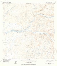
1952 Map of Talkeetna Mountains B-6
USGS Topo · Published 1952About this map
The Talkeetna River dominates this 1952 topographic study, winding through the expansive drainage basins of the Talkeetna Mountains. This map, based on aerial photography from August 1949, documents a landscape largely defined by its hydrological network, including Chunilna Creek and Disappointment Creek. Small Cabin sites are the only indicators of human presence in this part of the Alaska interior, suggesting the temporary seasonal dwellings of trappers or early prospectors. The terrain transitions from the low-lying Birch Creek valley to high elevations like Bald Mountain and the peak marked Roger. This edition is particularly interesting for its note on missing data in the west, where cloud cover during the 1949 aerial survey obscured certain areas from the multiplex mapping process.
Find a feature on this map
9 named features on this map. Tap any name to fly to it.
Don’t see what you’re looking for? This feature index may not catch every label — zoom into the map to look around manually.
Map Details
Editions of this 1952 Talkeetna Mountains B-6 Map
2 editions found
Other maps of this area

1949 · Talkeetna Mountains B-6
USGS Topo · 1:63,360

1949 · Talkeetna Mountains C-6
USGS Topo · 1:63,360

1950 · Talkeetna Mountains
USGS Topo · 1:250,000

1950 · Talkeetna
USGS Topo · 1:250,000

1950 · Talkeetna Mountains B-5
USGS Topo · 1:63,360

1950 · Talkeetna Mountains A-6
USGS Topo · 1:63,360

1950 · Talkeetna Mountains A-5
USGS Topo · 1:63,360

1950 · Talkeetna Mountains C-5
USGS Topo · 1:63,360

1951 · Talkeetna
USGS Topo · 1:250,000

1951 · Talkeetna B-1
USGS Topo · 1:63,360