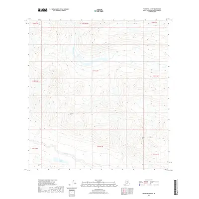
2017 Map of Talkeetna A-5 SW
USGS Topo · Published 2017About this map
Johnson Creek meanders through the high terrain of the Matanuska-Susitna region, defining the drainage patterns across this Alaskan landscape. To the south, the Happy River cuts through the territory near Finnbear Lake, a notable water body situated at the base of the Long Lake Hills. The topography is dominated by prominent summits such as Columbia Peak and McDoel Peak, which provide fixed reference points in a region primarily defined by its elevation changes and natural waterways. This 2017 survey reflects the remote character of the borough, showing a landscape shaped by glacial and fluvial processes with very few signs of human development or infrastructure.
Find a feature on this map
15 named features on this map. Tap any name to fly to it.
Don’t see what you’re looking for? This feature index may not catch every label — zoom into the map to look around manually.
Map Details
Editions of this 2017 Talkeetna A-5 SW Map
This is the sole edition of this map. No revisions or reprints were ever made.
Other maps of this area

1949 · Tyonek
USGS Topo · 1:250,000

1950 · Talkeetna
USGS Topo · 1:250,000

1951 · Talkeetna
USGS Topo · 1:250,000

1951 · Tyonek
USGS Topo · 1:250,000

1958 · Talkeetna A-6
USGS Topo · 1:63,360

1958 · Tyonek D-6
USGS Topo · 1:63,360

1958 · Talkeetna A-5
USGS Topo · 1:63,360

1958 · Tyonek
USGS Topo · 1:250,000

1958 · Talkeetna
USGS Topo · 1:250,000
1958 · Tyonek D-7
USGS Topo · 1:63,360