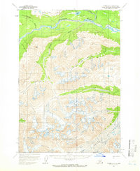
1958 Map of Tyonek D-7
USGS Topo · Published 1966About this map
The Old Iditarod Trail (Winter Trail) traverses this 1950s landscape, following the northern bank of the Skwentna River near its confluence with the Happy River. This historic route highlights the area's role in early Alaskan transport before modern aviation replaced overland winter travel. The northern half of the region is defined by these river systems and scattered landmarks like Shirley Lake and Long Lake, while the southern half transitions into high-altitude terrain dominated by the massive Hayes Glacier. Navigating the ice-carved topography, explorers of the era identified numerous Crevasses near Alger Peak. The drainage patterns of Chickak River, Old Man Creek, and Spring Creek further emphasize the complex hydrologic network feeding from the glacial highlands into the lower river valleys.
Find a feature on this map
15 named features on this map. Tap any name to fly to it.
Don’t see what you’re looking for? This feature index may not catch every label — zoom into the map to look around manually.
Map Details
Editions of this 1958 Tyonek D-7 Map
2 editions found
Other maps of this area

1949 · Tyonek
USGS Topo · 1:250,000

1950 · Talkeetna
USGS Topo · 1:250,000

1951 · Talkeetna
USGS Topo · 1:250,000

1951 · Tyonek
USGS Topo · 1:250,000

1958 · Talkeetna A-6
USGS Topo · 1:63,360

1958 · Tyonek C-6
USGS Topo · 1:63,360

1958 · Tyonek D-6
USGS Topo · 1:63,360

1958 · Talkeetna A-5
USGS Topo · 1:63,360

1958 · Tyonek C-8
USGS Topo · 1:63,360

1958 · Tyonek D-8
USGS Topo · 1:63,360