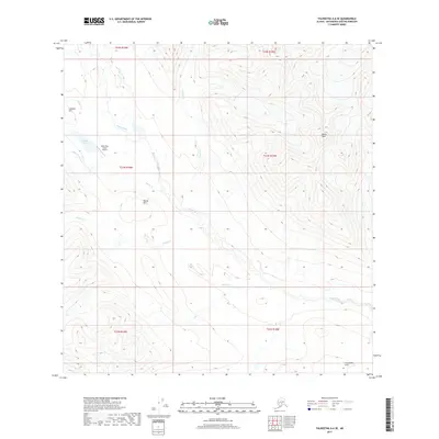
2017 Map of Talkeetna A-6 SE
USGS Topo · Published 2017About this map
Rainy Pass Lodge Airport serves as a remote hub in this high-elevation Alaskan landscape, situated near the shores of Puntilla Lake. The terrain is defined by a network of drainages including Happy River, Canyon Cr, and Glacier Cr, which carve through the Matanuska-Susitna interior. Surveyed in 2017, the map illustrates the complex topography of the region, anchored by prominent peaks and ridges such as Distin Peak, Round Mtn, and the Long Lake Hills. The drainage patterns, particularly where Squaw Cr and Indian Cr intersect the larger river valleys, suggest a wilderness landscape where aviation and river corridors provide the primary means of movement. This modern topographic study provides an exact record of the glacial valleys and summit elevations that characterize this portion of the Talkeetna Mountains.
Find a feature on this map
17 named features on this map. Tap any name to fly to it.
Don’t see what you’re looking for? This feature index may not catch every label — zoom into the map to look around manually.
Map Details
Editions of this 2017 Talkeetna A-6 SE Map
This is the sole edition of this map. No revisions or reprints were ever made.
Other maps of this area

1949 · Tyonek
USGS Topo · 1:250,000

1950 · Talkeetna
USGS Topo · 1:250,000

1951 · Talkeetna
USGS Topo · 1:250,000

1951 · Tyonek
USGS Topo · 1:250,000

1958 · Talkeetna A-6
USGS Topo · 1:63,360

1958 · Talkeetna A-5
USGS Topo · 1:63,360

1958 · Tyonek D-8
USGS Topo · 1:63,360

1958 · Tyonek
USGS Topo · 1:250,000

1958 · Talkeetna
USGS Topo · 1:250,000
1958 · Tyonek D-7
USGS Topo · 1:63,360