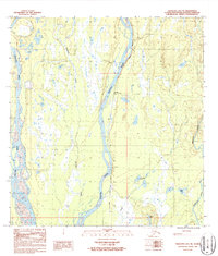
1987 Map of Talkeetna B-1 NE
USGS Topo · Published 1987About this map
The Susitna River and the Alaska Railroad dominate this 1980s landscape, illustrating the critical transportation corridor north of the Talkeetna townsite. The settlement of Chase serves as a focal point along the rail line, surrounded by a complex network of glacial tributaries and wetlands. The confluence of major waterways like the Chulitna River and Chunilna Creek with the Susitna creates a landscape defined by seasonal flow and shifting river channels. Smaller named water bodies such as Snowflake Lake, Debore Lake, and Willie Lake are scattered across the terrain, while landmarks like Whiskers Creek and a localized Gravel Pit indicate specific points of early infrastructure and geographic reference in this Matanuska-Susitna Borough interior.
Find a feature on this map
15 named features on this map. Tap any name to fly to it.
Don’t see what you’re looking for? This feature index may not catch every label — zoom into the map to look around manually.
Map Details
Editions of this 1987 Talkeetna B-1 NE Map
This is the sole edition of this map. No revisions or reprints were ever made.
Other maps of this area

1949 · Talkeetna Mountains B-6
USGS Topo · 1:63,360

1949 · Talkeetna Mountains C-6
USGS Topo · 1:63,360

1950 · Talkeetna Mountains
USGS Topo · 1:250,000

1950 · Talkeetna
USGS Topo · 1:250,000

1951 · Talkeetna
USGS Topo · 1:250,000

1951 · Talkeetna B-1
USGS Topo · 1:63,360

1951 · Talkeetna C-1
USGS Topo · 1:63,360

1952 · Talkeetna Mountains C-6
USGS Topo · 1:63,360

1952 · Talkeetna Mountains B-6
USGS Topo · 1:63,360

1954 · Talkeetna Mountains
USGS Topo · 1:250,000