
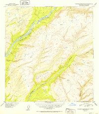
1952 Map of Talkeetna Mountains C-6
USGS Topo · Published 1952About this map
The Alaska Railroad follows the wide valley of the Susitna River in this early 1950s survey of the Alaska interior. The rail line serves as the primary corridor of movement through this region of the Talkeetna Mountains, passing the settlement at Sherman and several benchmarked peaks. Numerous watercourses, including Troublesome Creek, Deadhorse Creek, and Lane Creek, drain from the higher elevations toward the main river channel.
Find a feature on this map
13 named features on this map. Tap any name to fly to it.
Don’t see what you’re looking for? This feature index may not catch every label — zoom into the map to look around manually.
Map Details
Editions of this 1952 Talkeetna Mountains C-6 Map
2 editions found
Other maps of this area

1949 · Talkeetna Mountains D-6
USGS Topo · 1:63,360

1949 · Talkeetna Mountains B-6
USGS Topo · 1:63,360

1949 · Talkeetna Mountains C-6
USGS Topo · 1:63,360

1950 · Talkeetna Mountains
USGS Topo · 1:250,000

1950 · Talkeetna
USGS Topo · 1:250,000

1950 · Talkeetna Mountains B-5
USGS Topo · 1:63,360

1950 · Talkeetna Mountains D-5
USGS Topo · 1:63,360

1950 · Talkeetna Mountains C-5
USGS Topo · 1:63,360

1951 · Talkeetna
USGS Topo · 1:250,000

1951 · Talkeetna B-1
USGS Topo · 1:63,360