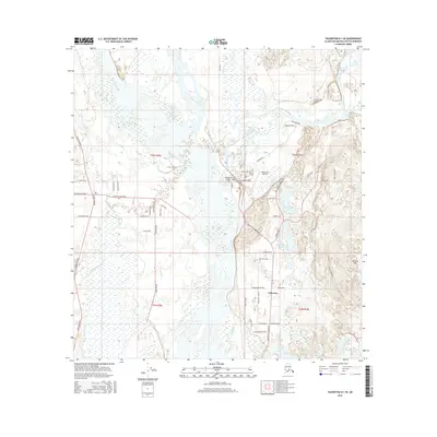
2016 Map of Talkeetna B-1 SE
USGS Topo · Published 2016About this map
The confluence of three major waterways—the Susitna River, Chulitna River, and Talkeetna River—defines the orientation of this 2016 survey. The village of Talkeetna is situated on the eastern bank of the Susitna, featuring a distinctive street grid and the adjacent Talkeetna Village Strip. The map illustrates a landscape shaped by water and transport, where the Talkeetna Airport and the Parks Highway provide modern access to this Alaskan interior. To the east, the Bartlett Hills rise above a series of kettle lakes, including Christiansen Lake, Talkeetna Lakes, and Fish Lake. A network of smaller creeks and sloughs, such as Birch Creek Slough and Whiskey Slough, carve through the glacial outwash plain. The local road system, including Petersville Road and Talkeetna Spur Road, reveals the expansion of the community through named tracks like Pow Wow Trail and Wolf Track Road.
Find a feature on this map
65 named features on this map. Tap any name to fly to it.
Don’t see what you’re looking for? This feature index may not catch every label — zoom into the map to look around manually.
Map Details
Editions of this 2016 Talkeetna B-1 SE Map
This is the sole edition of this map. No revisions or reprints were ever made.
Other maps of this area

1949 · Talkeetna Mountains B-6
USGS Topo · 1:63,360

1950 · Talkeetna Mountains
USGS Topo · 1:250,000

1950 · Talkeetna
USGS Topo · 1:250,000

1950 · Talkeetna Mountains A-6
USGS Topo · 1:63,360

1951 · Talkeetna
USGS Topo · 1:250,000

1951 · Talkeetna B-1
USGS Topo · 1:63,360

1952 · Talkeetna Mountains B-6
USGS Topo · 1:63,360

1952 · Talkeetna A-1
USGS Topo · 1:63,360
1952 · Talkeetna Mountains A-6
USGS Topo · 1:63,360

1954 · Talkeetna Mountains
USGS Topo · 1:250,000