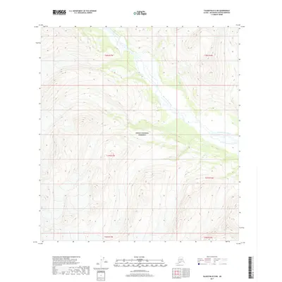
2017 Map of Talkeetna B-5 NW
USGS Topo · Published 2017About this map
Denali National Preserve encompasses the heart of this landscape, where the braided channels of the West Fork Yentna River migrate across a wide glacial valley. This 2017 survey documents a high-altitude wilderness within the Matanuska-Susitna region, defined by steep contour intervals and complex drainage patterns. The map highlights the intersection of several townships, including t27n r17w and t28n r16w, providing a precise look at the Public Land Survey System grid as it overlays the natural topography of the Alaska Range's southern reaches. The absence of roads or permanent structures underscores the protected status of the preserve, making this an essential record for those studying the hydrography and geomorphology of the Yentna River system in its modern state.
Find a feature on this map
8 named features on this map. Tap any name to fly to it.
Don’t see what you’re looking for? This feature index may not catch every label — zoom into the map to look around manually.
Map Details
Editions of this 2017 Talkeetna B-5 NW Map
This is the sole edition of this map. No revisions or reprints were ever made.
Other maps of this area

1950 · Talkeetna
USGS Topo · 1:250,000

1951 · Talkeetna
USGS Topo · 1:250,000

1958 · Talkeetna B-5
USGS Topo · 1:63,360

1958 · Talkeetna B-6
USGS Topo · 1:63,360

1958 · Talkeetna C-6
USGS Topo · 1:63,360

1958 · Talkeetna C-5
USGS Topo · 1:63,360

1958 · Talkeetna
USGS Topo · 1:250,000

1965 · Talkeetna
USGS Topo · 1:250,000
2017 · Talkeetna C-5 SE
USGS Topo · 1:25,000
2017 · Talkeetna C-6 SE
USGS Topo · 1:25,000