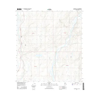
2016 Map of Talkeetna C-1 SE
USGS Topo · Published 2016About this map
The Susitna River and Chulitna River dominate this Alaskan landscape, defining the transportation and settlement corridors of the Matanuska-Susitna region. The eastern side of the survey highlights Curry, a historically significant stop along the Alaska Railroad, while Chase is situated further south along the same riverbank. These locations reflect the area's reliance on rail and water transport before the full integration of the modern highway system. On the western edge, the Parks Highway runs parallel to the Chulitna, supported by aviation access at Mc Kinley Country Airport and Songlo Vista Airport. Numerous tributaries such as Whiskers Cr, Portage Cr, and McKenzie Cr carve through the terrain, illustrating the complex drainage patterns that characterize this subarctic wilderness at the dawn of the 21st century.
Find a feature on this map
17 named features on this map. Tap any name to fly to it.
Don’t see what you’re looking for? This feature index may not catch every label — zoom into the map to look around manually.
Map Details
Editions of this 2016 Talkeetna C-1 SE Map
This is the sole edition of this map. No revisions or reprints were ever made.
Other maps of this area
1949 · Talkeetna Mountains B-6
USGS Topo · 1:63,360
1949 · Talkeetna Mountains C-6
USGS Topo · 1:63,360
1950 · Talkeetna Mountains
USGS Topo · 1:250,000
1950 · Talkeetna
USGS Topo · 1:250,000
1951 · Talkeetna
USGS Topo · 1:250,000
1951 · Talkeetna B-1
USGS Topo · 1:63,360
1951 · Talkeetna C-1
USGS Topo · 1:63,360
1952 · Talkeetna Mountains C-6
USGS Topo · 1:63,360
1952 · Talkeetna Mountains B-6
USGS Topo · 1:63,360
1954 · Talkeetna Mountains
USGS Topo · 1:250,000