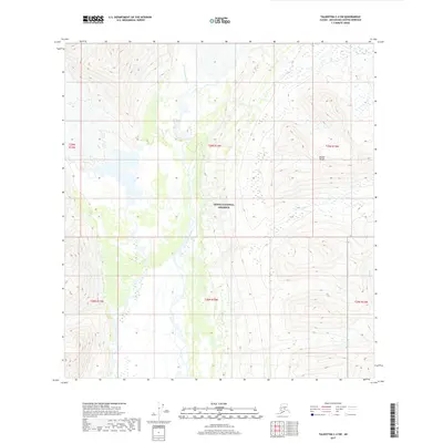
2017 Map of Talkeetna C-4 SW
USGS Topo · Published 2017About this map
Denali National Preserve encompasses a significant portion of this terrain in the Matanuska-Susitna region, where the high slopes of the Alaska Range overlook a complex network of glacial meltwater. The drainage of the E Fork Yentna River, also labeled as the East Fork Yentna River, dominates the central landscape. The river creates a broad, braided channel system that cuts through the topography, reflecting the dynamic hydrological environment of the Alaskan interior. In the southeastern corner, the smaller Idaho Cr winds through the lower elevations. The map is defined by its lack of human infrastructure, focusing instead on the natural transition from high alpine ridges to the river basins below, providing a clear view of the wilderness before more recent geological or environmental shifts.
Find a feature on this map
11 named features on this map. Tap any name to fly to it.
Don’t see what you’re looking for? This feature index may not catch every label — zoom into the map to look around manually.
Map Details
Editions of this 2017 Talkeetna C-4 SW Map
This is the sole edition of this map. No revisions or reprints were ever made.
Other maps of this area

1950 · Talkeetna
USGS Topo · 1:250,000

1951 · Talkeetna
USGS Topo · 1:250,000

1954 · Talkeetna B-4
USGS Topo · 1:63,360

1958 · Talkeetna B-5
USGS Topo · 1:63,360

1958 · Talkeetna C-4
USGS Topo · 1:63,360

1958 · Talkeetna C-5
USGS Topo · 1:63,360

1958 · Talkeetna
USGS Topo · 1:250,000

1965 · Talkeetna
USGS Topo · 1:250,000
2014 · Talkeetna C-4 NW
USGS Topo · 1:25,000
2014 · Talkeetna C-4 NE
USGS Topo · 1:25,000