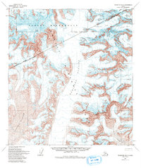
1958 Map of Talkeetna D-3
USGS Topo · Published 1993About this map
Mount Foraker and Mount Hunter anchor this mid-century survey of the high Alaska Range, documented before the formal designation of the surrounding Denali Wilderness. The landscape is dominated by a complex network of ice and rock, with the massive Kahiltna Glacier flowing south between massive peaks. This 1958 edition provides a detailed record of glacial extents, capturing the positions of the Tokositna Glacier, Lacuna Glacier, and Kanikula Glacier during a period of intense aerial mapping. The map also delineates the Matanuska-Susitna Borough Boundary and the convergence of the Seward and Fairbanks Meridians. High-altitude landmarks like Avalanche Spire and One Shot Gap offer specific points of interest for mountaineering history and topographic study in the heart of what is now Denali National Park.
Find a feature on this map
16 named features on this map. Tap any name to fly to it.
Don’t see what you’re looking for? This feature index may not catch every label — zoom into the map to look around manually.
Map Details
Editions of this 1958 Talkeetna D-3 Map
4 editions found

Other maps of this area

1950 · Talkeetna
USGS Topo · 1:250,000

1951 · Talkeetna
USGS Topo · 1:250,000

1952 · Mount McKinley
USGS Topo · 1:250,000

1953 · Mount McKinley A-4
USGS Topo · 1:63,360

1954 · Mount McKinley A-4
USGS Topo · 1:63,360

1954 · Mount McKinley A-2
USGS Topo · 1:63,360

1954 · Mount McKinley A-3
USGS Topo · 1:63,360

1958 · Talkeetna C-4
USGS Topo · 1:63,360

1958 · Talkeetna C-2
USGS Topo · 1:63,360

1958 · Talkeetna D-4
USGS Topo · 1:63,360