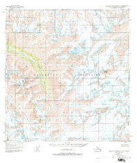
1949 Map of Talkeetna Mountains A-4
USGS Topo · Published 1977About this map
The Talkeetna Mountains define this high-altitude landscape in the Matanuska-Susitna region, as documented through photogrammetric methods from aerial photography taken in 1949. This map focuses on the high-elevation glacial system and headwaters, where the Sheep River originates amidst a complex of massive ice fields. The eastern portion of the sheet is dominated by the Talkeetna Glacier and the Chickaloon Glacier, reflecting the ice-bound character of the region before late-20th-century climatic shifts. Sovereign Mountain stands as a primary landmark within this unsurveyed territory, where land lines remain largely predetermined by the Bureau of Land Management rather than established by field crews. The topographic data reveals a land defined entirely by ice and altitude, without recorded roads, trails, or permanent settlements at the time of the 1949 survey.
Find a feature on this map
5 named features on this map. Tap any name to fly to it.
Don’t see what you’re looking for? This feature index may not catch every label — zoom into the map to look around manually.
Map Details
Editions of this 1949 Talkeetna Mountains A-4 Map
2 editions found
Other maps of this area

1948 · Anchorage D-4
USGS Topo · 1:63,360

1949 · Anchorage D-5
USGS Topo · 1:63,360

1949 · Talkeetna Mountains A-4
USGS Topo · 1:63,360

1950 · Talkeetna Mountains
USGS Topo · 1:250,000

1950 · Talkeetna Mountains B-5
USGS Topo · 1:63,360

1950 · Talkeetna Mountains B-4
USGS Topo · 1:63,360

1950 · Anchorage D-6
USGS Topo · 1:63,360

1950 · Talkeetna Mountains A-5
USGS Topo · 1:63,360

1951 · Anchorage
USGS Topo · 1:250,000

1951 · Talkeetna Mountains B-3
USGS Topo · 1:63,360