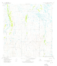
1951 Map of Talkeetna Mountains B-1
USGS Topo · Published 1976About this map
Big Bones Ridge forms a massive topographic spine in this portion of the Talkeetna Mountains, dividing a complex network of glacial and snow-fed drainage systems. The landscape is defined by the broad valleys of the Oshetna River and Tyone Creek, where the terrain transitions from high ridges to intricate wetlands filled with unnamed ponds. Notable for its lack of human infrastructure, the area is instead marked by surveyors' lines like the Seward Meridian East Boundary, which cuts across a wilderness of creeks including Fourth of July Creek and Sanona Creek. The map documents a pristine interior Alaska before modern development, where the geography is dictated by water and rock rather than roads. Genealogists or researchers looking into the early surveying of the Matanuska-Susitna region will find the precise placement of family-named features like Yacko Creek and Walker Creek particularly valuable for anchoring historical movement through the territory.
Find a feature on this map
16 named features on this map. Tap any name to fly to it.
Don’t see what you’re looking for? This feature index may not catch every label — zoom into the map to look around manually.
Map Details
Editions of this 1951 Talkeetna Mountains B-1 Map
3 editions found
Other maps of this area

1949 · Talkeetna Mountains A-1
USGS Topo · 1:63,360

1949 · Gulkana A-6
USGS Topo · 1:63,360

1950 · Talkeetna Mountains
USGS Topo · 1:250,000

1950 · Gulkana B-6
USGS Topo · 1:63,360

1951 · Gulkana
USGS Topo · 1:250,000

1951 · Talkeetna Mountains B-1
USGS Topo · 1:63,360

1951 · Talkeetna Mountains A-2
USGS Topo · 1:63,360

1951 · Talkeetna Mountains C-2
USGS Topo · 1:63,360

1951 · Talkeetna Mountains B-2
USGS Topo · 1:63,360

1951 · Talkeetna Mountains C-1
USGS Topo · 1:63,360