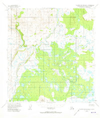
1951 Map of Talkeetna Mountains C-1
USGS Topo · Published 1973About this map
The Susitna River and its major tributaries dominate this subarctic landscape in the early 1950s, revealing an intricate network of waterways before modern development. The confluence of the Tyone River and the Oshetna River with the Susitna highlights the importance of these natural corridors for movement through the Matanuska-Susitna region. High points like Vabm 4503 Oshetna and Lone Butte provide relief over a terrain largely defined by low-lying swamps and smaller drainage systems including Tyone Creek and Sanona Creek. A lone Cabin situated near the Black River in the southwest corner represents the very sparse human footprint in this wilderness during the mid-century, while the Seward Meridian and East Boundary lines mark the early efforts of the Bureau of Land Management to survey and organize this remote Alaskan interior.
Find a feature on this map
11 named features on this map. Tap any name to fly to it.
Don’t see what you’re looking for? This feature index may not catch every label — zoom into the map to look around manually.
Map Details
Editions of this 1951 Talkeetna Mountains C-1 Map
3 editions found
Other maps of this area

1950 · Talkeetna Mountains
USGS Topo · 1:250,000

1950 · Gulkana B-6
USGS Topo · 1:63,360

1951 · Gulkana
USGS Topo · 1:250,000

1951 · Gulkana D-6
USGS Topo · 1:63,360

1951 · Talkeetna Mountains B-1
USGS Topo · 1:63,360

1951 · Talkeetna Mountains C-2
USGS Topo · 1:63,360

1951 · Talkeetna Mountains D-2
USGS Topo · 1:63,360

1951 · Talkeetna Mountains B-2
USGS Topo · 1:63,360

1951 · Talkeetna Mountains C-1
USGS Topo · 1:63,360

1951 · Talkeetna Mountains D-1
USGS Topo · 1:63,360