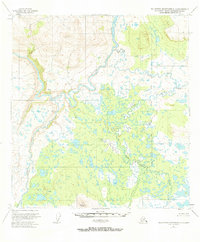
1951 Map of Talkeetna Mountains C-1
USGS Topo · Published 1973About this map
The Susitna River carves through this northern Alaskan landscape, joined by the Oshetna River and the braided reaches of the Tyone River. Surveyed in the early 1950s, the terrain is defined by an intricate network of wetlands, small lakes, and tributary streams like Sanona Creek and Goose Creek. High points are marked by survey markers such as Vabm 4503 Oshetna and Lone Butte Vabm 3648, which provide vertical orientation above the river valleys. A solitary Cabin sits near the Black River in the southwest, offering a rare sign of human habitation in a region otherwise dominated by the natural drainage patterns of the Tyone Creek system. The map captures the area as it existed before significant modern development, emphasizing the importance of the major river systems for navigation and local geography.
Find a feature on this map
12 named features on this map. Tap any name to fly to it.
Don’t see what you’re looking for? This feature index may not catch every label — zoom into the map to look around manually.
Map Details
Editions of this 1951 Talkeetna Mountains C-1 Map
3 editions found
Other maps of this area

1950 · Talkeetna Mountains
USGS Topo · 1:250,000

1950 · Gulkana B-6
USGS Topo · 1:63,360

1951 · Gulkana
USGS Topo · 1:250,000

1951 · Gulkana D-6
USGS Topo · 1:63,360

1951 · Talkeetna Mountains B-1
USGS Topo · 1:63,360

1951 · Talkeetna Mountains C-2
USGS Topo · 1:63,360

1951 · Talkeetna Mountains D-2
USGS Topo · 1:63,360

1951 · Talkeetna Mountains B-2
USGS Topo · 1:63,360

1951 · Talkeetna Mountains C-1
USGS Topo · 1:63,360

1951 · Talkeetna Mountains D-1
USGS Topo · 1:63,360