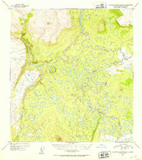
1952 Map of Talkeetna Mountains C-1
USGS Topo · Published 1953About this map
The Susitna River meanders through this portion of the Talkeetna Mountains, where the landscape is defined by an intricate network of waterways and glacial terrain. At this point in the early 1950s, the area remains largely undeveloped, with a single Cabin located near the confluence of the Oshetna River and the Black River in the southwest. The geography is characterized by extensive wetlands and thousands of small unnamed ponds that feed into tributaries like Tyone Creek and Sanona Creek. Survey markers like VABM 4503 Oshetna and Lone Butte VABM 3888 provide essential elevation data for this remote drainage basin, illustrating the complex hydrology of the Tyone River system before more modern infrastructure or settlement reached this interior region.
Find a feature on this map
10 named features on this map. Tap any name to fly to it.
Don’t see what you’re looking for? This feature index may not catch every label — zoom into the map to look around manually.
Map Details
Editions of this 1952 Talkeetna Mountains C-1 Map
2 editions found
Other maps of this area

1950 · Talkeetna Mountains
USGS Topo · 1:250,000

1950 · Gulkana B-6
USGS Topo · 1:63,360

1951 · Gulkana
USGS Topo · 1:250,000

1951 · Gulkana D-6
USGS Topo · 1:63,360

1951 · Talkeetna Mountains B-1
USGS Topo · 1:63,360

1951 · Talkeetna Mountains C-2
USGS Topo · 1:63,360

1951 · Talkeetna Mountains D-2
USGS Topo · 1:63,360

1951 · Talkeetna Mountains B-2
USGS Topo · 1:63,360

1951 · Talkeetna Mountains C-1
USGS Topo · 1:63,360

1951 · Talkeetna Mountains D-1
USGS Topo · 1:63,360