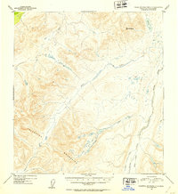
1952 Map of Talkeetna Mountains C-3
USGS Topo · Published 1953About this map
Mt Watana rises as the prominent landmark within this high-altitude region of the Talkeetna Mountains, as surveyed during the early 1950s. The landscape is defined by a complex drainage system where Fog Creek and Tsisi Creek carve through the high terrain. To the east, Watana Lake sits near the headwaters of several unnamed tributaries, illustrating the interior drainage patterns typical of the Alaska Range's southern reaches. The map identifies specific watercourses like Kosina Creek and John George Creek, which flow through valleys that had yet to see significant modern development. This document reflects the post-war efforts of the U.S. Geological Survey to systematically map the Alaskan interior using aerial photography, providing a detailed record of the wilderness before later shifts in land use and conservation.
Find a feature on this map
8 named features on this map. Tap any name to fly to it.
Don’t see what you’re looking for? This feature index may not catch every label — zoom into the map to look around manually.
Map Details
Editions of this 1952 Talkeetna Mountains C-3 Map
This is the sole edition of this map. No revisions or reprints were ever made.
Other maps of this area

1950 · Talkeetna Mountains
USGS Topo · 1:250,000

1950 · Talkeetna Mountains B-4
USGS Topo · 1:63,360

1951 · Talkeetna Mountains C-2
USGS Topo · 1:63,360

1951 · Talkeetna Mountains B-3
USGS Topo · 1:63,360

1951 · Talkeetna Mountains D-2
USGS Topo · 1:63,360

1951 · Talkeetna Mountains B-2
USGS Topo · 1:63,360

1951 · Talkeetna Mountains C-4
USGS Topo · 1:63,360

1951 · Talkeetna Mountains D-3
USGS Topo · 1:63,360

1951 · Talkeetna Mountains D-4
USGS Topo · 1:63,360

1951 · Talkeetna Mountains C-3
USGS Topo · 1:63,360