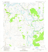
1951 Map of Talkeetna Mountains D-1
USGS Topo · Published 1965About this map
The Susitna River carves through this northern landscape, serving as a primary geographic marker alongside the Maclaren River at a time when the region remained largely undeveloped. This 1951 survey, based on 1949 photogrammetric data, captures the area during the mid-century period of Alaskan mapping. The map reveals a wild terrain defined by water and high peaks, including VABM 3716 Sumarildason and VABM 3299 Coal. Evidence of human presence is minimal, noted only by a solitary Cabin near the shores of Coal Lake. This specific alignment of the Seward Meridian and the South Boundary Fairbanks Meridian highlights the survey's role in formalizing the territorial grid across the Susitna basin's drainage systems, including Coal Creek and Clearwater Creek.
Find a feature on this map
11 named features on this map. Tap any name to fly to it.
Don’t see what you’re looking for? This feature index may not catch every label — zoom into the map to look around manually.
Map Details
Editions of this 1951 Talkeetna Mountains D-1 Map
3 editions found

Other maps of this area

1949 · Healy A-1
USGS Topo · 1:63,360

1950 · Talkeetna Mountains
USGS Topo · 1:250,000

1950 · Mount Hayes
USGS Topo · 1:250,000

1950 · Mount Hayes A-6
USGS Topo · 1:63,360

1951 · Healy
USGS Topo · 1:250,000

1951 · Gulkana
USGS Topo · 1:250,000

1951 · Mount Hayes
USGS Topo · 1:250,000

1951 · Gulkana D-6
USGS Topo · 1:63,360

1951 · Talkeetna Mountains C-2
USGS Topo · 1:63,360

1951 · Talkeetna Mountains D-2
USGS Topo · 1:63,360