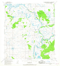
1951 Map of Talkeetna Mountains D-1
USGS Topo · Published 1968About this map
The Susitna River and Maclaren River dominate this interior Alaskan landscape, which serves as a major geographical meeting point between three principal survey meridians. This 1951 edition highlights the convergence of the South Boundary Fairbanks Meridian, the Seward Meridian, and the East Boundary Seward Meridian, illustrating how early federal land management divided this expansive terrain. Evidence of early exploration and seasonal occupation is found in isolated landmarks like a lone Cabin near Coal Lake. Significant elevation points such as Vabm 3299 Coal and Vabm 3716 Richardson provide fixed survey markers amidst a complex network of waterways including Coal Creek and Clearwater Creek.
Find a feature on this map
11 named features on this map. Tap any name to fly to it.
Don’t see what you’re looking for? This feature index may not catch every label — zoom into the map to look around manually.
Map Details
Editions of this 1951 Talkeetna Mountains D-1 Map
3 editions found

Other maps of this area

1949 · Healy A-1
USGS Topo · 1:63,360

1950 · Talkeetna Mountains
USGS Topo · 1:250,000

1950 · Mount Hayes
USGS Topo · 1:250,000

1950 · Mount Hayes A-6
USGS Topo · 1:63,360

1951 · Healy
USGS Topo · 1:250,000

1951 · Gulkana
USGS Topo · 1:250,000

1951 · Mount Hayes
USGS Topo · 1:250,000

1951 · Gulkana D-6
USGS Topo · 1:63,360

1951 · Talkeetna Mountains C-2
USGS Topo · 1:63,360

1951 · Talkeetna Mountains D-2
USGS Topo · 1:63,360