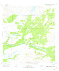
1951 Map of Talkeetna Mountains D-3
USGS Topo · Published 1975About this map
The Susitna River carves a deep path through the southern half of this interior landscape, which was mapped from 1949 aerial photography. The terrain is defined by a dense network of high-altitude waterways, including the winding Watana Creek and Deadman Creek which flow south toward the main river channel. This 1951 survey predates modern infrastructure, showing the vast Matanuska-Susitna region as it appeared before any roads or trails were established in this section of the Talkeetna Mountains. To the south, the clustered Fog Lakes and the adjacent Fog Creek sit above the river valley, while the north is marked by the North Boundary Seward Meridian. Notable water features such as Big Lake and Delusion Creek illustrate the glacial drainage patterns typical of the era's subarctic wilderness before significant human encroachment.
Find a feature on this map
8 named features on this map. Tap any name to fly to it.
Don’t see what you’re looking for? This feature index may not catch every label — zoom into the map to look around manually.
Map Details
Editions of this 1951 Talkeetna Mountains D-3 Map
3 editions found
Other maps of this area

1950 · Talkeetna Mountains
USGS Topo · 1:250,000

1950 · Healy A-3
USGS Topo · 1:63,360

1950 · Healy A-4
USGS Topo · 1:63,360

1951 · Healy
USGS Topo · 1:250,000

1951 · Talkeetna Mountains C-2
USGS Topo · 1:63,360

1951 · Talkeetna Mountains D-2
USGS Topo · 1:63,360

1951 · Talkeetna Mountains C-4
USGS Topo · 1:63,360

1951 · Talkeetna Mountains D-3
USGS Topo · 1:63,360

1951 · Talkeetna Mountains D-4
USGS Topo · 1:63,360

1951 · Talkeetna Mountains C-3
USGS Topo · 1:63,360